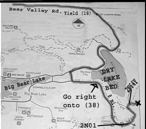


Heres
the Map

Heres the directions:
Bear Valley Rd. East, yield right onto Highway 18
Continue on 18 towards Big Bear Lake(yield right)
Continue past Cement Factory, up mountian.
Continue past Dry lake bed, and make a left onto
Division Rd(any road that will get you to other side of lake)
Then make a left again onto Big Bear Blvd.
Yield right onto the 38 from Big Bear Blvd.
Continue on 38 for ruffly 8 miles, make a left onto
'2N01' a quater mile after a '8000ft elavation' sign.
*note, the 2N01 turnoff is a dirt road, that is hard to see.
Once on 2N01, continue for 2-4 miles then make a right onto
2N64Y, then continue for a quater mile, and have fun camping!
If you're coming from redlands/riverside area do this:
Take the I-10 E exit towards REDLANDS. 0.68 miles
Merge onto I-10 E. 7.09 miles
Take the UNIVERSITY STREET exit. 0.26 miles
Turn LEFT onto N UNIVERSITY ST. 0.98 miles
Turn RIGHT onto E LUGONIA AVE/CA-38. 1.63 miles
E LUGONIA AVE/CA-38 becomes MENTONE BLVD/CA-38. 2.00 miles
MENTONE BLVD/CA-38 becomes MILL CREEK RD/CA-38. 3.14 miles
MILL CREEK RD/CA-38 becomes CA-38.
Continue on 38, make a RIGHT onto
'2N01' a quater mile before a '8000ft elavation' sign, so if you go too far you'll know.
*note, the 2N01 turnoff is a dirt road, that is hard to see.
Once on 2N01, continue for 2-4 miles then make a right onto
2N64Y, then continue for a quater mile, and have fun camping!
click here for the actually flyer


